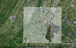
Overlaying a map on top of a section of Google Earth was pretty fun. Honestly, I think the hardest part of this assignment was finding a decent picture to overlay with. The rest of the assignment was rather straight-forward.
I chose to focus on Loudoun County, which is the county I have lived in my whole life. I found a pretty basic illustration of the county online and decided to use it. After opening Google Earth, I flew to Loudoun County and placed the map I found on top of the Google Earth image. Scaling and arranging the two layers was not as difficult as I had imagined and only took a matter of a few minutes. It was helpful to look at natural features, such as the Potomac River. I also had a boundary layer on in Google Earth, which made matching county lines fast and easy.
One cool thing about overlaying an image onto another map is the ability to view the differences in the two images. I liked playing with the transparency in order to see what changes occurred. I think this is critical to historians who want to show change over time or development of a certain area. I found it especially interesting to see differences in roads and towns.
Anyway, here is a picture of what my final result came to be:


certainly like your website but you have to check the spelling on quite a few of your posts.
Many of them are rife with spelling problems and I find it very
troublesome to inform the truth then again I will
definitely come again again.
my page – yahoo search (https://www.yahoo.com)